|
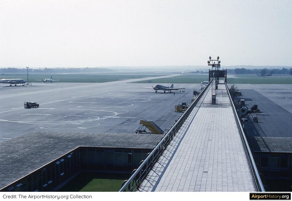
,Following the recent 62nd anniversary of the modernized and expanded London Gatwick Airport, we went digging in our extensive AirportHistory archives. From this, we found a batch of very rare color images of the airport taken shortly after opening of the newly-built terminal. Have a good look and enjoy! A (VERY) SHORT HISTORY Initially known as the Surrey Aero Club, Gatwick had existed since 1930. Four years later, Gatwick, located 30 miles (48 kilometers) south of Central London, became the reliever airport for Croydon Airport, then the main airport for London. Two years later, in 1936, the trendsetting "Beehive" terminal was dedicated. Among others, the Beehive featured predecessors of the modern boarding bridge. In July 1952, it was decided to modernize and expand Gatwick. The airport was to serve as a reliever airport for Heathrow--then still called London Airport--focusing on flights to the Channel Islands and Mediterranean holiday destinations. The Stage 1 scheme involved the erection of a box-like terminal building and pier, the construction of a new railway station to serve the airport, and a 7,000-foot (2,134-meter) single runway with associated high-speed taxiways, parking areas and aprons. On June 9th, 1958, the expanded London Gatwick Airport was dedicated by the Queen. Having cost GBP 7.8 million, Gatwick became the first airport in the world with an integrated railway station. Now, without further ado, let's have a look at the images! 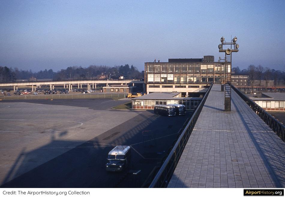 An image taken from the airfield operations control room, looking east toward the terminal building. The terminal, designed by Yorke, Rosenberg & Mardall, boasted three levels and was designed with expansion in mind. These gentlemen certainly were no Eero Saarinen (designer of Washington Dulles Airport and the TWA Flight Center in New York)! Then again, this building is still part of the current complex today. As I often say, the boxes last longest! 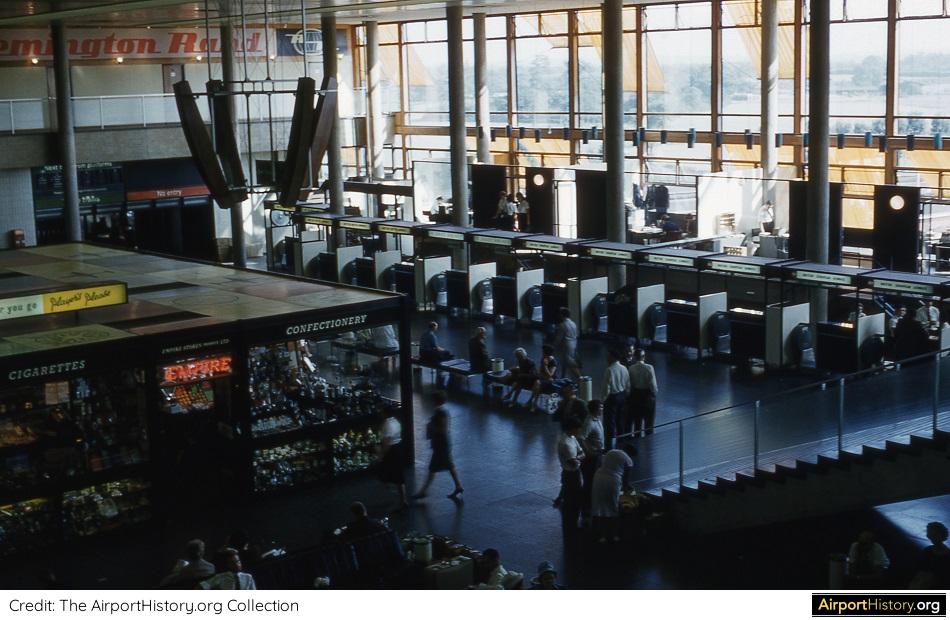 A 1958 interior view of the concourse level of the terminal, taken from the mezzanine level. The Stage 1 terminal measured 350 by 130 feet (107 x 40 meter) and contained two rows of check-in desks, the other row being located to the left of the image behind the shops. Airline offices were located behind the check-in desks. The advertisement in the back at the mezzanine level reads "Remington Rand", an American company that made office equipment, including typewriters. 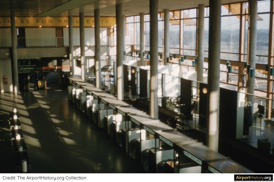 Another view looking east toward the exit toward the train station, which was connected to the eastern end of the terminal. A small curbside was located to the north of the terminal, or toward the left in this picture. I assume "Business for Prosperity" was a typical post-war reconstruction slogan but could not find a reference to it on the web. 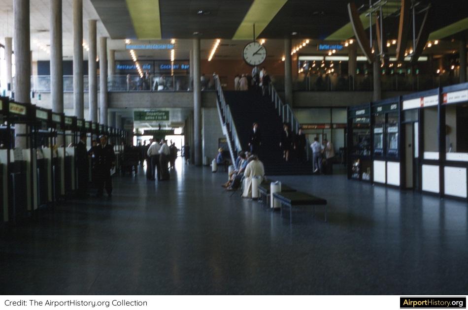 Unfortunately the quality of this image is not optimal but it's too interesting to exclude. This view looks east toward the pier. Check in desks are located to the left and right. The green sign at the end reads "departure gates 1 to 18". The mezzanine level contained bars and restaurants. The blue signs read "restaurant and cocktail bar" and "buffet and bar". 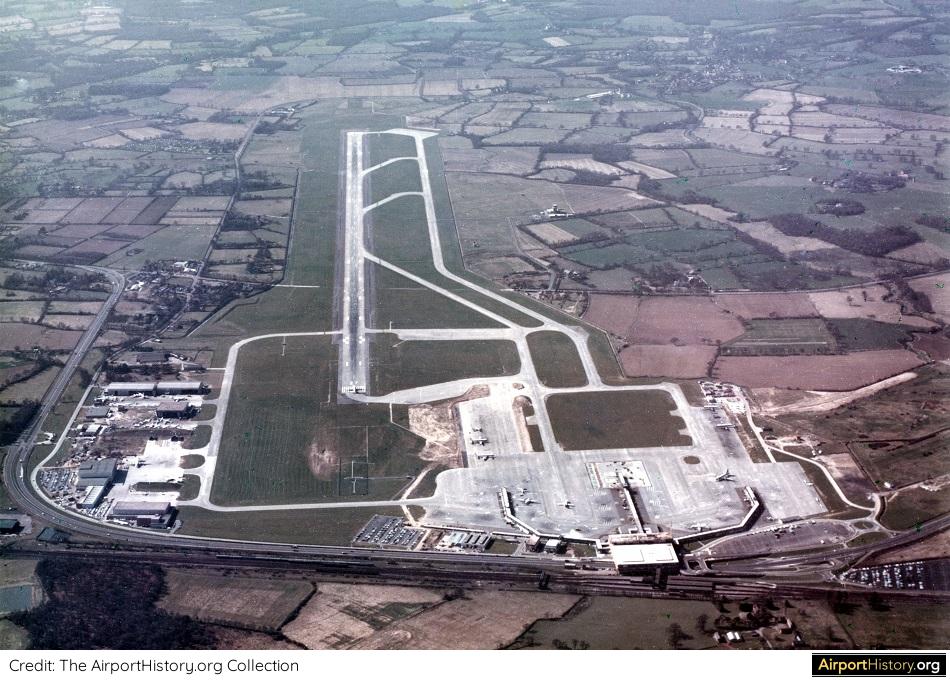 This image is actually not from 1958. This aerial view was taken some time after completion of the airport's expansion in 1965, which included the doubling of the terminal, the construction of two more piers and extension of the runway to 8,200 feet (2,500 meters), making it suitable for jets. Color aerials from this period are very rare, which is why I wanted to include it. We hope you enjoyed these photos. Do you remember visiting 1950s and 1960s Gatwick? Leave a comment below!
In the future, we'll be posting a full history on Gatwick Airport as well as more themed photo specials. Want to explore more airport history? Sign up for our newsletter here or follow us on social media!
4 Comments
After almost 40 years of operation, the TWA Flight Center was closed in October 2001, just before TWA itself ceased to exist (the airline was absorbed into American Airlines).
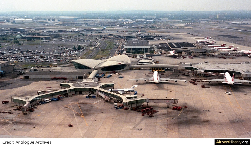
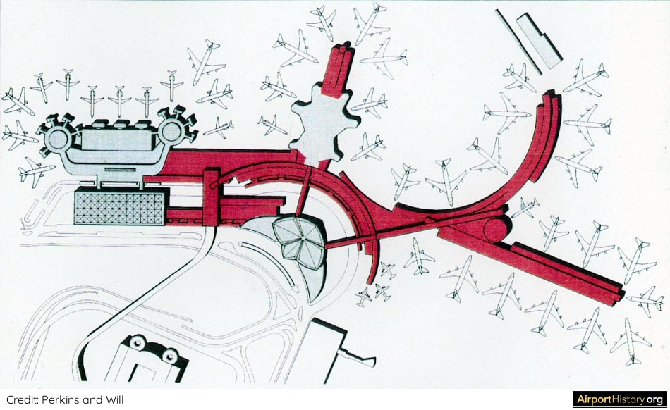
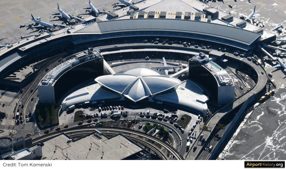
Thankfully, the TWA Flight Center had been able to acquire landmark status and escape the wrecking ball, contrary to other illustrious JFK terminals such as the Pan Am Worldport and the Sundrome, A new Terminal 5, operated by JetBlue, opened on October 22, 2008. The entry hall of the newer Gensler designed terminal wraps around the former terminal in a crescent shape. Although the old satellite buildings, called "Flight Wing One" and "Flight Wing Two", were demolished, the original tube connectors leading passengers from the terminal building, called the "head house", were retained. After standing empty for nearly two decades, the TWA Flight Center found a new life. In May 2019, the TWA Hotel opened to the public. Although commercially the hotel has had a bumpy take-off, it has become a place of pilgrimage for aviation geeks from around the world. However, did you know that back in 1990 a plan was developed to expand the TWA Flight Center? If built, the terminal might still have been with us today as a working terminal, instead of a hotel. A 1990 PLAN FOR A REVAMPED TWA FLIGHT CENTER By the 1980s, the deficiencies of the TWA Flight Center had become very apparent. The terminal had too little of everything: gates, check-in space, baggage handling facilities, curb space, etc. In 1990, Trans World Airlines--at the time still in a relatively healthy state--commissioned Perkins and Will to work on a redevelopment project for its whole JFK complex, which by then included the former National terminal, a.k.a. the Sundrome.
NEW FLIGHT WING TWO
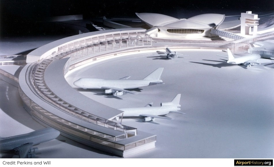
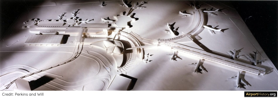
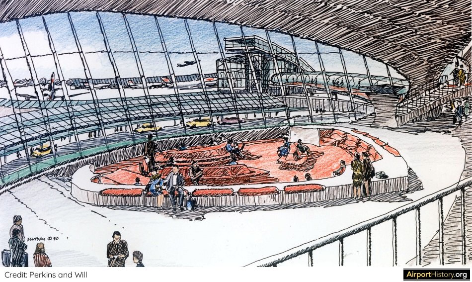
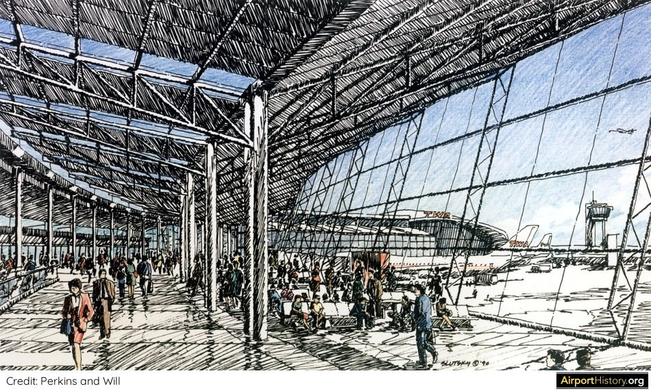
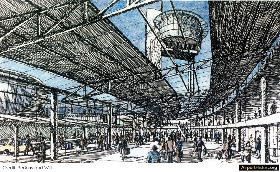
The most radical feature of the proposed scheme was a complete replacement of the original Flight Wing Two satellite building. It would be replaced by a "Y"-shaped 20-gate concourse, with most stands being able to accommodate wide-body aircraft. Having been opened in 1970, Flight Wing One, was still a relatively young structure at the time, and thus was maintained with an extension being added. A new Federal Inspection Services (FIS) facility, "meeters and greeters" hall and arrival roadway would be built in a curved shape around the iconic TWA head house. These were all planned to be depressed below the apron level to preserve the openness and views to the airfield from the head house. Wow!
FLIGHT CENTER BECOMES CHECK-IN FACILITY
The head house itself would be used for check-in. One of the adjoining wings would have been expanded to accommodate more check-in desks for international flights. The famous concrete connector tubes leading from the head house to the flight wings would have been replaced with glassed-in tubes equipped with escalators. Interestingly, in the original design for the Flight Center, the tubes featured escalators and a glass roof. However, the design was simplified in an attempt to contain the cost of the project. CONNECTION BETWEEN TERMINALS The then-existing corridor between the Flight Center and the Sundrome would be replaced with a large connecting structure, containing baggage transfer facilities and an expanded domestic baggage claim area. In between the terminal was a people mover station. The tracks would lead to a newly-built central terminal building, which was part of the shelved JFK 2000 Master Plan (which will be discussed in a later article). See more from the models and renditions of the plan below.
PUBLIC RESPONSE
The plan aroused great public concern and a campaign was launched to protect the Flight Center, which culminated in the Landmarks Preservation Commission granting landmark status for the exterior and some of the interiors on July 19, 1994. In addition, the protection status included Flight Wing Two in its entirety. In the end, the redevelopment did not go ahead as TWA reduced the scale of its operations and retrenched back to the Saarinen building. The rest, as they say, is airport history!
MY TAKE
Even after 30 years, the proposed design for the expansion of the TWA Flight Center still looks pretty nice! It also seemed to be an effective solution as well, providing a huge expansion, while still being very respectful toward the original Flight Center head house--even putting the arrival facilities below grade just to maintain a nice ramp view from the lounge! I was not able to locate any budget estimates but it seemed like it was a costly solution. Even in 1990, TWA was not in a state to afford a project like that. Alas, it did not come to be. As an airport planner and fan, I actually don't like terminals being converted to alternative uses such as shopping malls, entertainment centers or hotels. The best use of an airport terminal is...as an airport terminal. Having said this, the most important thing is the that the Flight Center is still around and I'm happy to have it anyway I can! What are your thoughts on the scheme? Would it have been a better solution? Let us know in the comments below!
ACKNOWLEDGEMENTS
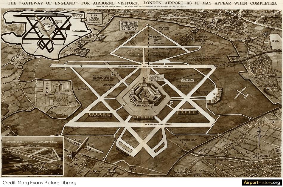
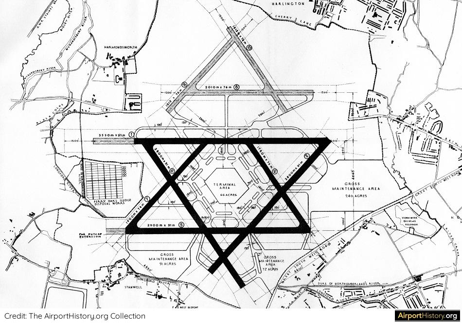
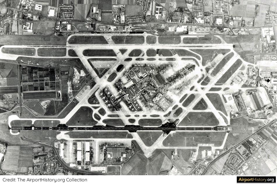
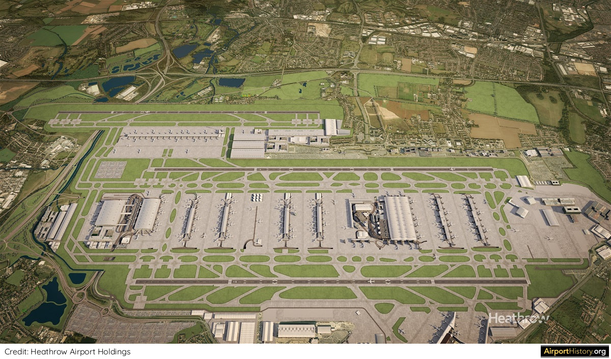
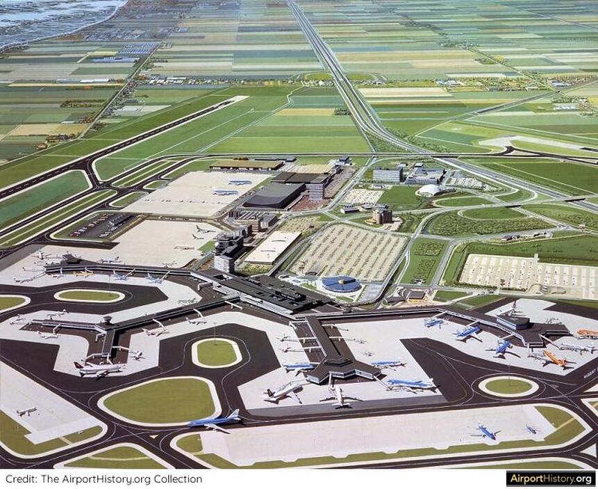
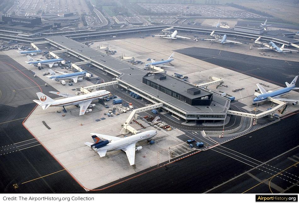
I would like to thank Audrey Barsella of Perkins & Will. Without her kind assistance this article would not have been possible. ALL GOOD THINGS TAKE TIME In democracies, development of big infrastructure projects can take decades. This especially applies to airports, which have a huge impact beyond their perimeter. For example, Amsterdam Schiphol's newest runway opened in 2003, 35 years after it first appeared in planning documents. London Heathrow's third runway takes the cake however. Did you know that plans to construct new runways north of Heathrow date back all the way to 1946? NINE RUNWAYS According to the airport's original development plan, initially Heathrow would boast six runways laid out in a Star-of-David pattern: two main east-west runways, which could handle the heaviest aircraft of the time, along with four shorter diagonal runways. Passenger terminals were to be located in the middle of the field in order to optimize aircraft taxiing times to and from the runways. In a second development phase, a further three runways in a triangular pattern would be built north of Bath Road, bringing the total to nine runways! The expansion would have necessitated the demolition of the two nearby villages of Harlington and Sipson. The Illustrated London News article mentioned that: "This work will not be undertaken before 1950 in order to... give ample warning to the householders concerned." The first six runways as well as the central terminal area were built as planned. The northward expansion, however, was thought to be costly and unnecessary, and plans were shelved. FROM SIX RUNWAYS TO TWO Due the expansion of the central terminal area, as well as the new generation of jets needing longer runways, three of Heathrow's four diagonal runways had been closed by the 1970s, leaving Heathrow with three runways. The last remaining diagonal runway, runway 5/23, was decommissioned in 2003, leaving Heathrow with its current two runways. Discussions about the construction of a third parallel runway resurfaced again in the 1980s. Between 1990 and 2015, three major studies were undertaken, all of which concluded that a third runway at Heathrow afforded the greatest benefits. THE THIRD RUNWAY IS FINALLY COMING...OR NOT? In 2018, the UK House of Commons voted in favor of the expansion, after which a public consultation started. According to the planning, the third runway would open in 2026, 80 years after it was first conceived! However, in February 2020, plans were blocked by an appeals court on environmental grounds. At the time of writing, the project could face many more years of delays, and with climate change now becoming a political priority, there is a chance that the scheme will be cancelled altogether. You can read many more details about Heathrow's history in the book Heathrow Airport 70 years and Counting, written by aviation journalist Kevan James. You can find more analysis on the recent court decision his website KJM Today. What are your thoughts about London's third runway project? Let us know in the comments below! More airport articles: Click here AMSTERDAM SCHIPHOL IN THE MID-1980S As the aviation community celebrates the 100th anniversary of KLM, AirportHistory.org is preparing a detailed history on Schiphol Airport, which actually predates KLM by more than three years! To get in the mood, I wanted to share this amazing illustration below of Amsterdam Schiphol Airport in the mid-1980s. When I was a kid, I used to have this image as a huge poster. I was so happy to find it back during one of my recent archival digs! It shows the Schiphol that I knew as a kid: state-of-the-art, small and convenient! Since then, the terminal has doubled in size and several new concourses have been built and existing ones extended. Have a close look at the details of the photo. The round structure adjacent to the terminal (center of image) is the "old" railway station. Opened in 1978, the station was torn down after only 15 years and rebuilt into the "Schiphol Plaza" complex we know today. Can some of you still remember the tunnel connecting the railway station to the terminal? Note the open parking lot on the right, which is now a huge multi-level parking structure with offices built on top. Also note the still-empty polder landscape south of the airport. The motorway running through it used to offer expansive views of the beautiful Dutch skies. Nowadays, the polder is cluttered with office parks, housing developments, infrastructure and--in the finest tradition--huge windmills! Foreign visitors in the image include 747s of Braniff, CP Air, Singapore Airlines and Qantas, as well as DC-10s of Malaysian Airline System and Finnair, as well as a DC-8 from Surinam Airways. Surinam is one of Holland's former colonies. Interestingly, you'll see planes are parked parallel to the concourse as well as nose-in. Indeed, for a number of years, Schiphol used a combination of the two, with newly built wide-body gates in the 1970s being nose-in positions. Gates for smaller aircraft were converted in the mid-1980s. SOMETHING IS NOT QUITE RIGHT I'm sure that readers familiar with Schiphol have already noticed that something about this illustration is "off" and that's what makes it so unique: Pier E, the second concourse from the right (then called Pier C) has been expanded with a "Y-shaped" structure, similar to the other piers. Indeed, this was originally the plan. But in the early 1980s, it was decided to completely rebuild Pier E, with the design departing from this "Y" shape. See below for how it turned out. From this interesting deviation and the visiting aircraft, I gather that the drawing dates back to the early 1980s or even late 1970s. I have been unable to properly identify the artist who made this drawing. Only his given name "Hubert" is visible on the edge of the drawing. Can one of our readers perhaps help? Hope you enjoyed! This was just a snapshot of Schiphol's history but we are working on a muti-part history as well as several photo specials.
Did you notice other interesting things about this illustration? Please share your thoughts below ↓ |
With a title inspired by the setting of the iconic 70s film "Airport", this blog is the ultimate destination for airport history fans.
Categories
All
About me
Marnix (Max) Groot Founder of AirportHistory.org. Max is an airport development expert and historian. |


 RSS Feed